
Thank you for supporting this site ❤️
Make a donation
Make a donation
Gear up for your next adventure:
As an Amazon Associate, this site earns from qualifying purchases at no extra cost to you.
Ellisfield topographic map
Click on the map to display elevation.
Thank you for supporting this site ❤️
Make a donation
Make a donation
Gear up for your next adventure:
As an Amazon Associate, this site earns from qualifying purchases at no extra cost to you.
About this map
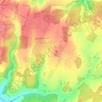
Name: Ellisfield topographic map, elevation, terrain.
Average elevation: 577 ft
Minimum elevation: 384 ft
Maximum elevation: 692 ft
Thank you for supporting this site ❤️
Make a donation
Make a donation
Gear up for your next adventure:
As an Amazon Associate, this site earns from qualifying purchases at no extra cost to you.
Other topographic maps
Click on a map to view its topography, its elevation and its terrain.
Cocksford Firs East
United Kingdom > England > Hampshire > Basingstoke and Deane > Steventon
Average elevation: 502 ft
Sherborne St John
United Kingdom > England > Hampshire > Basingstoke and Deane
Average elevation: 302 ft