
Make a donation
Gear up for your next adventure:
As an Amazon Associate, this site earns from qualifying purchases at no extra cost to you.
Langscheid topographic map
Click on the map to display elevation.
Make a donation
Gear up for your next adventure:
As an Amazon Associate, this site earns from qualifying purchases at no extra cost to you.
Langscheid
Über die Jahrhunderte variierte der Ortsname leicht – es finden sich nach der ersten Erwähnung 1253 als in Langesceider bach noch verschiedene Abwandlungen, bis im Jahr 1788 erstmals das heutige „Langscheid“ erscheint. Der Ortsname leitet sich von mittelhochdeutsch langen scheit = „beim langen bewaldeten Höhenrücken“ her.
Make a donation
Gear up for your next adventure:
As an Amazon Associate, this site earns from qualifying purchases at no extra cost to you.
About this map
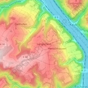
Name: Langscheid topographic map, elevation, terrain.
Average elevation: 863 ft
Minimum elevation: 233 ft
Maximum elevation: 1,394 ft
Make a donation
Gear up for your next adventure:
As an Amazon Associate, this site earns from qualifying purchases at no extra cost to you.