
Make a donation
Gear up for your next adventure:
As an Amazon Associate, this site earns from qualifying purchases at no extra cost to you.
Ribaforada topographic map
Click on the map to display elevation.
Make a donation
Gear up for your next adventure:
As an Amazon Associate, this site earns from qualifying purchases at no extra cost to you.
Ribaforada
Integrado en la comarca de La Ribera, se sitúa a 106 kilómetros de Pamplona. El término municipal está atravesado por la Autopista Vasco-Aragonesa (AP-68), por la Autovía del Ebro (A-68) y por carreteras locales que conectan con Ablitas (NA-3042), Buñuel (NA-5200) y Fustiñana (NA-5202). El relieve del municipio es prácticamente llano, destacando la presencia del río Ebro, el Canal Imperial de Aragón y el Canal de Lodosa. La altitud oscila entre los 340 metros al suroeste y los 240 metros a orillas del Ebro. El pueblo se alza a 262 metros sobre el nivel del mar.
Make a donation
Gear up for your next adventure:
As an Amazon Associate, this site earns from qualifying purchases at no extra cost to you.
About this map
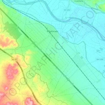
Name: Ribaforada topographic map, elevation, terrain.
Location: Ribaforada, Ribera, España (41.94156 -1.55635 42.02189 -1.48203)
Average elevation: 899 ft
Minimum elevation: 778 ft
Maximum elevation: 1,250 ft
Make a donation
Gear up for your next adventure:
As an Amazon Associate, this site earns from qualifying purchases at no extra cost to you.
Other topographic maps
Click on a map to view its topography, its elevation and its terrain.