
Make a donation
Gear up for your next adventure:
As an Amazon Associate, this site earns from qualifying purchases at no extra cost to you.
Trevignano Romano topographic map
Click on the map to display elevation.
Make a donation
Gear up for your next adventure:
As an Amazon Associate, this site earns from qualifying purchases at no extra cost to you.
About this map
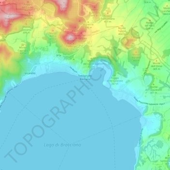
Name: Trevignano Romano topographic map, elevation, terrain.
Location: Trevignano Romano, Roma Capitale, Lazio, 00069, Italië (42.12110 12.19239 42.18290 12.31068)
Average elevation: 814 ft
Minimum elevation: 522 ft
Maximum elevation: 1,949 ft
Make a donation
Gear up for your next adventure:
As an Amazon Associate, this site earns from qualifying purchases at no extra cost to you.
Other topographic maps
Click on a map to view its topography, its elevation and its terrain.
Make a donation
Gear up for your next adventure:
As an Amazon Associate, this site earns from qualifying purchases at no extra cost to you.
Lago di Traiano
Italië > Lazio > Roma Capitale > Fiumicino > Episcopio di Porto
Average elevation: 10 ft