
Make a donation
Gear up for your next adventure:
As an Amazon Associate, this site earns from qualifying purchases at no extra cost to you.
San Severo topographic map
Click on the map to display elevation.
Make a donation
Gear up for your next adventure:
As an Amazon Associate, this site earns from qualifying purchases at no extra cost to you.
San Severo
The city sits in low-lying country, its center being at about 90 metres (300 ft) above sea level. Geologically, its soil is quaternary (with sand and clay, fossils, and marine in origin). Its territory decreases in elevation from the west 125 metres (410 ft) to the east 26 metres (85 ft), gradually changing from minor ripples in the western hills to a more regular plain in the east at the Candelaro basin.
Make a donation
Gear up for your next adventure:
As an Amazon Associate, this site earns from qualifying purchases at no extra cost to you.
About this map
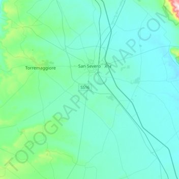
Name: San Severo topographic map, elevation, terrain.
Location: San Severo, Foggia, Apulia, 71016, Italy (41.54509 15.29715 41.77336 15.60629)
Average elevation: 282 ft
Minimum elevation: 69 ft
Maximum elevation: 2,008 ft
Make a donation
Gear up for your next adventure:
As an Amazon Associate, this site earns from qualifying purchases at no extra cost to you.
Other topographic maps
Click on a map to view its topography, its elevation and its terrain.