
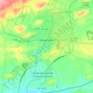
City of Gloversville topographic map
Interactive map
Click on the map to display elevation.
About this map
Name: City of Gloversville topographic map, elevation, terrain.
Average elevation: 860 ft
Minimum elevation: 669 ft
Maximum elevation: 1,234 ft
The city sits in the foothills of the Adirondack Mountains and therefore is within a climatic transition zone. Gloversville experiences the warmer summer temperatures common throughout the Capital Region, Hudson Valley, and Mohawk Valley while experiencing generally more copious precipitation throughout the year than the Capital Region. This manifests in commonplace rolling thunderstorms throughout the summer months and snowfall amounts more akin to the lake-pocked higher elevations of the Adirondacks in the winter months.
Other topographic maps
Click on a map to view its topography, its elevation and its terrain.
Town of Mayfield
United States > New York > Fulton County
Town of Mayfield, Fulton County, New York, 12117, United States
Average elevation: 1,096 ft
Town of Stratford
United States > New York > Fulton County
Town of Stratford, Fulton County, New York, 13470, United States
Average elevation: 1,585 ft
Village of Northville
United States > New York > Fulton County
Village of Northville, Town of Northampton, Fulton County, New York, United States
Average elevation: 869 ft
Town of Oppenheim
United States > New York > Fulton County
Town of Oppenheim, Fulton County, New York, United States
Average elevation: 994 ft
Lotville
United States > New York > Fulton County > Town of Oppenheim
Lotville, Town of Oppenheim, Fulton County, New York, United States
Average elevation: 1,086 ft
Town of Bleecker
United States > New York > Fulton County
Town of Bleecker, Fulton County, New York, United States
Average elevation: 1,644 ft
Otter Lake
United States > New York > Fulton County
Otter Lake, Town of Caroga, Fulton County, New York, United States
Average elevation: 1,814 ft
Town of Johnstown
United States > New York > Fulton County
Town of Johnstown, Fulton County, New York, United States
Average elevation: 1,043 ft
Caroga Lake
United States > New York > Fulton County
Caroga Lake, Town of Caroga, Fulton County, New York, United States
Average elevation: 1,526 ft
City of Johnstown
United States > New York > Fulton County
City of Johnstown, Fulton County, New York, 12095, United States
Average elevation: 732 ft
Village of Broadalbin
United States > New York > Fulton County
Village of Broadalbin, Town of Broadalbin, Fulton County, New York, United States
Average elevation: 866 ft
Pine Lake
United States > New York > Fulton County > Town of Caroga
Pine Lake, Town of Caroga, Fulton County, New York, United States
Average elevation: 1,696 ft
Oregon
United States > New York > Fulton County > Stratford > Oregon
Oregon, Stratford, Fulton County, New York, United States
Average elevation: 1,677 ft
Bleecker
United States > New York > Fulton County > Bleecker
Bleecker, Town of Bleecker, Fulton County, New York, United States
Average elevation: 1,594 ft
Fish House
United States > New York > Fulton County > Northampton > Fish House
Fish House, Northampton, Fulton County, New York, United States
Average elevation: 801 ft
West Caroga Lake
United States > New York > Fulton County > Town of Caroga > Caroga Lake
West Caroga Lake, Caroga Lake, Town of Caroga, Fulton County, New York, United States
Average elevation: 1,522 ft
Johnstown
United States > New York > Fulton County > Johnstown
Johnstown, City of Johnstown, Fulton County, New York, 12095, United States
Average elevation: 915 ft
Caroga Lake
United States > New York > Fulton County > Town of Caroga > Caroga Lake
Caroga Lake, Town of Caroga, Fulton County, New York, 12032, United States
Average elevation: 1,545 ft
Great Sacandaga Lake
United States > New York > Fulton County > Village of Northville
Great Sacandaga Lake, Village of Northville, Town of Northampton, Fulton County, New York, 12835, United States
Average elevation: 1,214 ft