Geolocate

Castle Pines topographic map

Click on the map to display elevation.

About this map

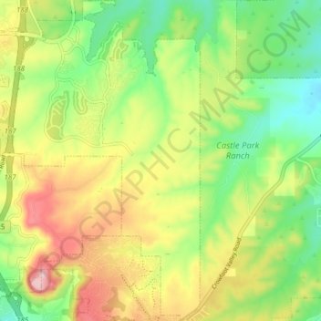
Name: Castle Pines topographic map, elevation, terrain.

Location: Castle Pines, Douglas County, Colorado, United States (39.41912 -104.87501 39.47823 -104.83021)

Average elevation: 6,352 ft

Minimum elevation: 6,073 ft

Maximum elevation: 6,719 ft

Douglas County trails, hiking, mountain biking, running and outdoor activities

Gear up for your next adventure:

🛡️Insect Repellent - Protection against bugs during outdoor activities
🔭Telescopic Hiking Pole - Adjustable pole for hiking stability
🧣Hiking Neck Gaiter - Multi‑use neck protection for outdoor weather
🪓Survival Multi‑Tool - Versatile tool for camp and trail tasks
📶Vehicle Signal Boosters - Improve reception in rural areas while driving to trailheads

As an Amazon Associate, this site earns from qualifying purchases at no extra cost to you.