
Make a donation
Gear up for your next adventure:
As an Amazon Associate, this site earns from qualifying purchases at no extra cost to you.
Pulvermaar topographic map
Click on the map to display elevation.
Make a donation
Gear up for your next adventure:
As an Amazon Associate, this site earns from qualifying purchases at no extra cost to you.
Pulvermaar
Das nahezu kreisrunde Maar hat steile trichterförmige Wände. Der Wasserspiegel des Maarsees liegt auf einer Höhe von 411 m ü. NHN; mit einer maximalen Wassertiefe von 72 m ist er der tiefste See der Vulkaneifel. Bei einem Durchmesser von knapp 700 m beträgt die Seefläche etwa 38,48 ha und ist damit nach der des Laacher Sees in der Osteifel die zweitgrößte in der Eifel. Die landschaftsprägende vulkanische Struktur des Pulvermaars von etwa 900 m × 950 m wird von verschiedenen anderen Maaren in der Westeifel übertroffen. Das Volumen des Maarsees beträgt etwa 1,2 Millionen m³.
Make a donation
Gear up for your next adventure:
As an Amazon Associate, this site earns from qualifying purchases at no extra cost to you.
About this map
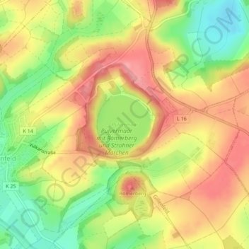
Name: Pulvermaar topographic map, elevation, terrain.
Average elevation: 1,404 ft
Minimum elevation: 1,227 ft
Maximum elevation: 1,542 ft
Make a donation
Gear up for your next adventure:
As an Amazon Associate, this site earns from qualifying purchases at no extra cost to you.