
Make a donation
Gear up for your next adventure:
As an Amazon Associate, this site earns from qualifying purchases at no extra cost to you.
Volksrust topographic map
Click on the map to display elevation.
Make a donation
Gear up for your next adventure:
As an Amazon Associate, this site earns from qualifying purchases at no extra cost to you.
Volksrust
The town was laid out in 1888 on the farms Boschpad Drift, Rooibult or Llanwarne, Verkyk and Zandfontein, and proclaimed in 1889. It lies at an elevation of 5,429 feet (1,655 m), and 4 miles (6.4 km) north of the pass through the Drakensberg known as Laing's Nek. Municipal status was attained in 1904.
Make a donation
Gear up for your next adventure:
As an Amazon Associate, this site earns from qualifying purchases at no extra cost to you.
About this map
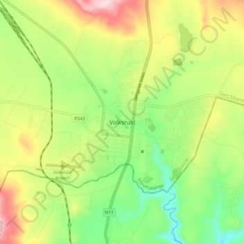
Name: Volksrust topographic map, elevation, terrain.
Average elevation: 5,538 ft
Minimum elevation: 5,023 ft
Maximum elevation: 6,263 ft
Make a donation
Gear up for your next adventure:
As an Amazon Associate, this site earns from qualifying purchases at no extra cost to you.