
Thank you for supporting this site ❤️
Make a donation
Make a donation
Gear up for your next adventure:
As an Amazon Associate, this site earns from qualifying purchases at no extra cost to you.
Ranjangaon topographic map
Click on the map to display elevation.
Thank you for supporting this site ❤️
Make a donation
Make a donation
Gear up for your next adventure:
As an Amazon Associate, this site earns from qualifying purchases at no extra cost to you.
About this map
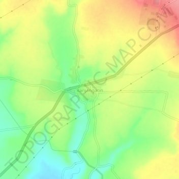
Name: Ranjangaon topographic map, elevation, terrain.
Location: Ranjangaon, Shirur, Pune District, Maharashtra, India (18.73364 74.22458 18.77364 74.26458)
Average elevation: 2,054 ft
Minimum elevation: 1,916 ft
Maximum elevation: 2,198 ft
Thank you for supporting this site ❤️
Make a donation
Make a donation
Gear up for your next adventure:
As an Amazon Associate, this site earns from qualifying purchases at no extra cost to you.