Geolocate

Enping topographic map

Click on the map to display elevation.

About this map

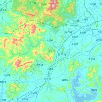
Name: Enping topographic map, elevation, terrain.

Location: Enping, Jiangmen, Guangdong Province, China (21.91561 111.99833 22.49499 112.52407)

Average elevation: 433 ft

Minimum elevation: -16 ft

Maximum elevation: 3,986 ft

Gear up for your next adventure:

🚁Photography Drones - Capture stunning aerial views of landforms and topography
👓Polarized Sunglasses - Outdoor sunglasses for glare reduction
🔌Solar Panel Charger - Charge gear sustainably outdoors
🔦Powerful Headlamps - Ultra-bright hands-free lighting for night navigation
🔥Camping Stove - Portable stove for camping and backcountry cooking

As an Amazon Associate, this site earns from qualifying purchases at no extra cost to you.