
Make a donation
Gear up for your next adventure:
As an Amazon Associate, this site earns from qualifying purchases at no extra cost to you.
Nordenau topographic map
Click on the map to display elevation.
Make a donation
Gear up for your next adventure:
As an Amazon Associate, this site earns from qualifying purchases at no extra cost to you.
Nordenau
Der kleine Ort mit alten, teilweise über 200 Jahre alten Fachwerkhäusern wird gekrönt von der Ruine des Bergfrieds der Burg Rappelstein, die einst Wanderern, Kaufleuten und Kriegern, die über die alte Heidenstraße, die hier über den Höhenrücken des Rothaargebirges führte, Schutz bot.
Make a donation
Gear up for your next adventure:
As an Amazon Associate, this site earns from qualifying purchases at no extra cost to you.
About this map
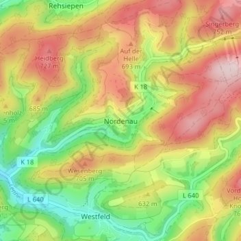
Name: Nordenau topographic map, elevation, terrain.
Average elevation: 2,037 ft
Minimum elevation: 1,506 ft
Maximum elevation: 2,589 ft
Make a donation
Gear up for your next adventure:
As an Amazon Associate, this site earns from qualifying purchases at no extra cost to you.
Other topographic maps
Click on a map to view its topography, its elevation and its terrain.
Esenbeck
Deutschland > Nordrhein-Westfalen > Hochsauerlandkreis > Schmallenberg > Obersorpe
Average elevation: 2,254 ft