
Ponteix topographic map
Click on the map to display elevation.
About this map
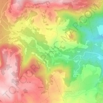
Name: Ponteix topographic map, elevation, terrain.
Average elevation: 2,674 ft
Minimum elevation: 2,001 ft
Maximum elevation: 3,205 ft
Other topographic maps
Click on a map to view its topography, its elevation and its terrain.
Lac d'Aydat
France > Auvergne-Rhône-Alpes > Puy-de-Dôme > Aydat > Sauteyras
Average elevation: 2,917 ft
Lac de la Cassière
France > Auvergne-Rhône-Alpes > Puy-de-Dôme > Aydat > La Cassière
Le lac de la Cassière se situe sur la commune d'Aydat, à côté du village de La Cassière, à environ 17 kilomètres de Clermont-Ferrand. Le lac de la Cassière est situé à 861 mètres d'altitude.
Average elevation: 2,989 ft