Geolocate

Varigotti topographic map

Click on the map to display elevation.

About this map

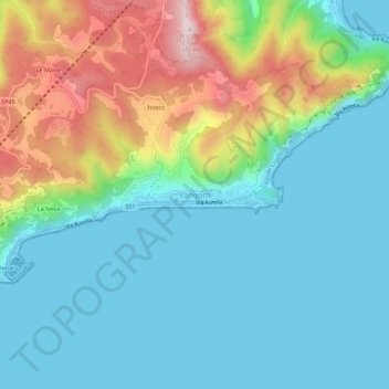
Name: Varigotti topographic map, elevation, terrain.

Location: Varigotti, Finale Ligure, Savona, Liguria, 17026, Italy (44.16244 8.37536 44.20244 8.41536)

Average elevation: 328 ft

Minimum elevation: -3 ft

Maximum elevation: 1,207 ft

Gear up for your next adventure:

🖼️Topo Map Wall Art - Decorative topographic prints of famous peaks and regions
🌧️Backpack Rain Cover - Keep gear dry in wet weather
🔭Telescopic Hiking Pole - Adjustable pole for hiking stability
🧤Hiking Gloves - Protective gloves for rugged trails
🪶Multi‑Purpose Knife - Useful blade for camp and trail

As an Amazon Associate, this site earns from qualifying purchases at no extra cost to you.