Geolocate

Rucas topographic map

Click on the map to display elevation.

About this map

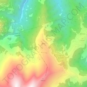
Name: Rucas topographic map, elevation, terrain.

Location: Rucas, Bagnolo Piemonte, Cuneo, Piemonte, Italia (44.73755 7.19867 44.77755 7.23867)

Average elevation: 4,186 ft

Minimum elevation: 2,362 ft

Maximum elevation: 6,588 ft

Gear up for your next adventure:

🗻Climbing Gear Basics - Essential gear for beginner climbers
📱Heavy-Duty Phone Cases - Drop-proof and waterproof protection for outdoor navigation
🧦Merino Wool Socks - Moisture-wicking, blister-preventing socks for long treks
Backpacking Tents - Weight-optimized shelters for multi-day topographic surveys
🧭Compass with Lanyard - Easy‑carry compass for navigation

As an Amazon Associate, this site earns from qualifying purchases at no extra cost to you.