
Sunken Meadow topographic map
Click on the map to display elevation.
About this map
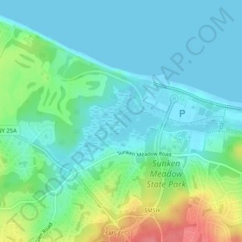
Name: Sunken Meadow topographic map, elevation, terrain.
Average elevation: 59 ft
Minimum elevation: -3 ft
Maximum elevation: 233 ft
Other topographic maps
Click on a map to view its topography, its elevation and its terrain.
Kings Park
United States > New York > Suffolk County > Town of Smithtown > Kings Park
Average elevation: 105 ft
Saint James
United States > New York > Suffolk County > Town of Smithtown > Saint James
Average elevation: 128 ft
Village of Nissequogue
United States > New York > Suffolk County > Town of Smithtown
Average elevation: 62 ft
Nesconset
United States > New York > Suffolk County > Town of Smithtown > Nesconset
Average elevation: 102 ft
Kings Park
United States > New York > Suffolk County > Town of Smithtown > Kings Park
Average elevation: 105 ft
Village of Head of the Harbor
United States > New York > Suffolk County > Town of Smithtown
Average elevation: 115 ft
Kings Park
United States > New York > Suffolk County > Town of Smithtown > Kings Park
Average elevation: 105 ft
Millers Pond
United States > New York > Suffolk County > Town of Smithtown > Village of the Branch
Average elevation: 66 ft
Village of the Branch
United States > New York > Suffolk County > Town of Smithtown
Average elevation: 82 ft
Village of Nissequogue
United States > New York > Suffolk County > Town of Smithtown
Average elevation: 62 ft