
Make a donation
Gear up for your next adventure:
As an Amazon Associate, this site earns from qualifying purchases at no extra cost to you.
Ashland topographic map
Click on the map to display elevation.
Make a donation
Gear up for your next adventure:
As an Amazon Associate, this site earns from qualifying purchases at no extra cost to you.
Ashland
Ashland lies within Oregon's southwest interior climate zone, in which all but the higher-elevation sites are in the rain shadow of the Oregon Coast Range to the west. The largest urban areas in this zone in addition to Ashland are Medford and Grants Pass in the Rogue Valley, and Roseburg in the Umpqua River Valley further north. Although the mountain peaks in this zone receive up to 120 inches or 3,050 millimetres of precipitation a year, the urban areas and the valleys in which they lie generally get 20 inches (510 mm) or less. This valley climate is particularly good for growing fruit, especially pears, and for producing other crops and farm goods such as hay, grain, poultry, and beef.
Make a donation
Gear up for your next adventure:
As an Amazon Associate, this site earns from qualifying purchases at no extra cost to you.
About this map
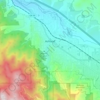
Name: Ashland topographic map, elevation, terrain.
Location: Ashland, Jackson County, Oregon, 95520, United States (42.16720 -122.73599 42.21605 -122.65110)
Average elevation: 2,539 ft
Minimum elevation: 1,650 ft
Maximum elevation: 4,846 ft
Jackson County trails, hiking, mountain biking, running and outdoor activities
Make a donation
Gear up for your next adventure:
As an Amazon Associate, this site earns from qualifying purchases at no extra cost to you.
Other topographic maps
Click on a map to view its topography, its elevation and its terrain.
Mount McLoughlin
United States > Oregon > Jackson County
The major landmark for the Rogue River Valley, Mount McLoughlin reaches an elevation of 9,493 ft (2,893 m). The tallest volcano in between Mount Shasta — located 70 mi (110 km) to the south — and South Sister 120 miles (190 km) to the north, it lies in the Cascade Range, in the southern portion of the U.S.…
Average elevation: 7,533 ft
Make a donation
Gear up for your next adventure:
As an Amazon Associate, this site earns from qualifying purchases at no extra cost to you.
Make a donation
Gear up for your next adventure:
As an Amazon Associate, this site earns from qualifying purchases at no extra cost to you.
Siskiyou Gap
United States > Oregon > Jackson County
"The original pass crosses the divide between the Rogue and Klamath Rivers at a slight topographic notch formed by the geological contact between the older Siskiyou Mountains to the west and the younger volcanic Cascade Range to the east." (Jeffrey M. LaLande, retired, forest archaeologist, Rogue…
Average elevation: 5,728 ft
Make a donation
Gear up for your next adventure:
As an Amazon Associate, this site earns from qualifying purchases at no extra cost to you.