
Make a donation
Gear up for your next adventure:
As an Amazon Associate, this site earns from qualifying purchases at no extra cost to you.
Niederzwehren topographic map
Click on the map to display elevation.
Make a donation
Gear up for your next adventure:
As an Amazon Associate, this site earns from qualifying purchases at no extra cost to you.
Niederzwehren
Nach Norden hin wird Niederzwehren in Richtung Park Schönfeld und Wehlheiden durch die nach Wilhelmshöhe abzweigende Verbindung der Waldkappeler Bahn begrenzt.
Make a donation
Gear up for your next adventure:
As an Amazon Associate, this site earns from qualifying purchases at no extra cost to you.
About this map
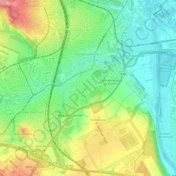
Name: Niederzwehren topographic map, elevation, terrain.
Location: Niederzwehren, Kassel, Hessen, 34134, Deutschland (51.26038 9.44844 51.29999 9.49103)
Average elevation: 568 ft
Minimum elevation: 430 ft
Maximum elevation: 794 ft
Make a donation
Gear up for your next adventure:
As an Amazon Associate, this site earns from qualifying purchases at no extra cost to you.
Other topographic maps
Click on a map to view its topography, its elevation and its terrain.
Karlsaue
Deutschland > Hessen > Kassel
In der Nähe des Sees steht eine Stieleiche mit einem Brusthöhenumfang von 7,95 m (2015).
Average elevation: 499 ft
Make a donation
Gear up for your next adventure:
As an Amazon Associate, this site earns from qualifying purchases at no extra cost to you.