
Thank you for supporting this site ❤️
Make a donation
Make a donation
Gear up for your next adventure:
As an Amazon Associate, this site earns from qualifying purchases at no extra cost to you.
200m topographic map
Click on the map to display elevation.
Thank you for supporting this site ❤️
Make a donation
Make a donation
Gear up for your next adventure:
As an Amazon Associate, this site earns from qualifying purchases at no extra cost to you.
About this map
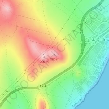
Name: 200m topographic map, elevation, terrain.
Location: 200m, Pájara, Las Palmas, Canary Islands, ES35627, Spain (28.15696 -14.24226 28.15706 -14.24216)
Average elevation: 285 ft
Minimum elevation: 0 ft
Maximum elevation: 636 ft
Thank you for supporting this site ❤️
Make a donation
Make a donation
Gear up for your next adventure:
As an Amazon Associate, this site earns from qualifying purchases at no extra cost to you.