
Thank you for supporting this site ❤️
Make a donation
Make a donation
Gear up for your next adventure:
As an Amazon Associate, this site earns from qualifying purchases at no extra cost to you.
Mailasqui topographic map
Click on the map to display elevation.
Thank you for supporting this site ❤️
Make a donation
Make a donation
Gear up for your next adventure:
As an Amazon Associate, this site earns from qualifying purchases at no extra cost to you.
About this map
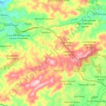
Name: Mailasqui topographic map, elevation, terrain.
Average elevation: 3,077 ft
Minimum elevation: 2,503 ft
Maximum elevation: 3,691 ft
Thank you for supporting this site ❤️
Make a donation
Make a donation
Gear up for your next adventure:
As an Amazon Associate, this site earns from qualifying purchases at no extra cost to you.
Other topographic maps
Click on a map to view its topography, its elevation and its terrain.
Morro do Saboó
Brasil > São Paulo > Região Metropolitana de Sorocaba > São Roque
Average elevation: 2,543 ft
Parquinho dos Coelhos
Brasil > São Paulo > Região Metropolitana de Sorocaba > São Roque
Average elevation: 2,927 ft