
Lacs du Castor topographic map
Interactive map
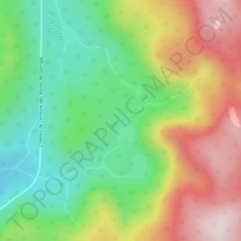
Click on the map to display elevation.
About this map
Name: Lacs du Castor topographic map, elevation, terrain.
Average elevation: 2,707 ft
Minimum elevation: 1,955 ft
Maximum elevation: 3,724 ft
Other topographic maps
Click on a map to view its topography, its elevation and its terrain.
Gaspésie
Canada > Quebec > La Haute-Gaspésie > Mont-Albert
Gaspésie, Mont-Albert, La Haute-Gaspésie, Gaspésie–Îles-de-la-Madeleine, Quebec, Canada
Average elevation: 1,506 ft
Rapide Blanc
Canada > Quebec > La Haute-Gaspésie > Mont-Albert
Rapide Blanc, Mont-Albert, La Haute-Gaspésie, Gaspésie–Îles-de-la-Madeleine, Quebec, Canada
Average elevation: 1,217 ft
Rapide Blanc
Canada > Quebec > La Haute-Gaspésie > Mont-Albert
Rapide Blanc, Mont-Albert, La Haute-Gaspésie, Gaspésie–Îles-de-la-Madeleine, Quebec, Canada
Average elevation: 1,037 ft