
Make a donation
Gear up for your next adventure:
As an Amazon Associate, this site earns from qualifying purchases at no extra cost to you.
Gerhardshofen topographic map
Click on the map to display elevation.
Make a donation
Gear up for your next adventure:
As an Amazon Associate, this site earns from qualifying purchases at no extra cost to you.
About this map
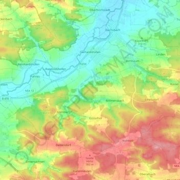
Name: Gerhardshofen topographic map, elevation, terrain.
Average elevation: 1,079 ft
Minimum elevation: 906 ft
Maximum elevation: 1,312 ft
Make a donation
Gear up for your next adventure:
As an Amazon Associate, this site earns from qualifying purchases at no extra cost to you.
Other topographic maps
Click on a map to view its topography, its elevation and its terrain.
Vockenroth
Deutschland > Bayern > Landkreis Neustadt an der Aisch-Bad Windsheim
Average elevation: 1,220 ft
Prühl
Deutschland > Bayern > Landkreis Neustadt an der Aisch-Bad Windsheim
Average elevation: 1,329 ft
Rother Berg
Deutschland > Bayern > Landkreis Neustadt an der Aisch-Bad Windsheim > Weigenheim
Average elevation: 1,217 ft
Sintmannsbuch
Deutschland > Bayern > Landkreis Neustadt an der Aisch-Bad Windsheim > Kästel
Average elevation: 1,152 ft
Make a donation
Gear up for your next adventure:
As an Amazon Associate, this site earns from qualifying purchases at no extra cost to you.
Altselingsbach
Deutschland > Bayern > Landkreis Neustadt an der Aisch-Bad Windsheim
Average elevation: 1,263 ft
Wulkersdorf
Deutschland > Bayern > Landkreis Neustadt an der Aisch-Bad Windsheim > Emskirchen
Average elevation: 1,220 ft
Obernesselbach
Deutschland > Bayern > Landkreis Neustadt an der Aisch-Bad Windsheim > Neustadt an der Aisch
Im Geographischen statistisch-topographischen Lexikon von Franken (1801) wird der Ort folgendermaßen beschrieben.
Average elevation: 1,138 ft
Altschauerberg
Deutschland > Bayern > Landkreis Neustadt an der Aisch-Bad Windsheim
Das Dorf liegt an einem namenlosen Bach, der ein rechter Zufluss der Mittleren Aurach ist. Der Ort ist im Norden und Osten vom Waldgebiet Hoch und im Süden vom Kalbsholz umgeben. 0,75 km südwestlich liegt die Egertenhöhe (405 m ü. NHN). Eine Gemeindeverbindungsstraße führt nach Neuschauerberg zur…
Average elevation: 1,243 ft
Make a donation
Gear up for your next adventure:
As an Amazon Associate, this site earns from qualifying purchases at no extra cost to you.
Ulsenheim
Deutschland > Bayern > Landkreis Neustadt an der Aisch-Bad Windsheim
Average elevation: 1,178 ft
Uffenheim
Deutschland > Bayern > Landkreis Neustadt an der Aisch-Bad Windsheim > Uffenheim > Uffenheim
Average elevation: 1,158 ft
Birkenfeld
Deutschland > Bayern > Landkreis Neustadt an der Aisch-Bad Windsheim > Neustadt an der Aisch
Average elevation: 1,050 ft
Pirkach
Deutschland > Bayern > Landkreis Neustadt an der Aisch-Bad Windsheim
Average elevation: 1,227 ft
Make a donation
Gear up for your next adventure:
As an Amazon Associate, this site earns from qualifying purchases at no extra cost to you.
Ingolstadt
Deutschland > Bayern > Landkreis Neustadt an der Aisch-Bad Windsheim
Average elevation: 1,093 ft
Steinach an der Ens
Deutschland > Bayern > Landkreis Neustadt an der Aisch-Bad Windsheim
Average elevation: 1,309 ft
Muna-Siedlung
Deutschland > Bayern > Landkreis Neustadt an der Aisch-Bad Windsheim
Average elevation: 1,463 ft
Abteiberg
Deutschland > Bayern > Landkreis Neustadt an der Aisch-Bad Windsheim > Markt Taschendorf
Average elevation: 1,227 ft
Make a donation
Gear up for your next adventure:
As an Amazon Associate, this site earns from qualifying purchases at no extra cost to you.
Ickelheim
Deutschland > Bayern > Landkreis Neustadt an der Aisch-Bad Windsheim > Bad Windsheim
Average elevation: 1,099 ft
Dettendorf
Deutschland > Bayern > Landkreis Neustadt an der Aisch-Bad Windsheim
Average elevation: 1,152 ft
Neidhardswinden
Deutschland > Bayern > Landkreis Neustadt an der Aisch-Bad Windsheim
Average elevation: 1,266 ft
Pilsenmühle
Deutschland > Bayern > Landkreis Neustadt an der Aisch-Bad Windsheim > Hagenhofen
Average elevation: 1,289 ft
Make a donation
Gear up for your next adventure:
As an Amazon Associate, this site earns from qualifying purchases at no extra cost to you.
Stübach
Deutschland > Bayern > Landkreis Neustadt an der Aisch-Bad Windsheim
Das Pfarrdorf liegt gegenüber dem Weiler Hanbach am Nordufer und linkem Talhang des unteren Ehebachs, eines linken und zugleich des größten Zuflusses der Aisch, auf Höhen von ca. 285–395 m ü. NHN. Der Altbach zweigt sich etwas oberhalb ab, er fließt an der Straßenbrücke der Kreisstraße NEA 15 wieder…
Average elevation: 1,079 ft
Altmannshausen
Deutschland > Bayern > Landkreis Neustadt an der Aisch-Bad Windsheim > Markt Bibart
Average elevation: 1,070 ft
Abtsgreuth
Deutschland > Bayern > Landkreis Neustadt an der Aisch-Bad Windsheim
Average elevation: 1,165 ft
Rennersberg
Deutschland > Bayern > Landkreis Neustadt an der Aisch-Bad Windsheim > Ipsheim
Average elevation: 1,283 ft
Make a donation
Gear up for your next adventure:
As an Amazon Associate, this site earns from qualifying purchases at no extra cost to you.
Oberniederndorf
Deutschland > Bayern > Landkreis Neustadt an der Aisch-Bad Windsheim
Average elevation: 1,155 ft
Borbath
Deutschland > Bayern > Landkreis Neustadt an der Aisch-Bad Windsheim
Average elevation: 1,171 ft
Breithart
Deutschland > Bayern > Landkreis Neustadt an der Aisch-Bad Windsheim > Burgbernheim
Average elevation: 1,437 ft
Hirschneuses
Deutschland > Bayern > Landkreis Neustadt an der Aisch-Bad Windsheim
Average elevation: 1,276 ft
Make a donation
Gear up for your next adventure:
As an Amazon Associate, this site earns from qualifying purchases at no extra cost to you.
Bruckenmühle
Deutschland > Bayern > Landkreis Neustadt an der Aisch-Bad Windsheim > Diespeck
Die Einöde liegt etwa 600 Meter nordwestlich des am rechten Flusstalhang angelegten Kerns des Hauptortes Diespeck am linken Ufer der Aisch, die hier einen kurzen Mühlkanal-Zweig hat. Etwa 350 Meter nordöstlich mündet flussabwärts der Ehebach von Westen her in diese. Jenseits des Ehebachs liegt im…
Average elevation: 1,027 ft
Neuschauerberg
Deutschland > Bayern > Landkreis Neustadt an der Aisch-Bad Windsheim
Average elevation: 1,234 ft
Obersachsen
Deutschland > Bayern > Landkreis Neustadt an der Aisch-Bad Windsheim
Average elevation: 1,152 ft
Brunn
Deutschland > Bayern > Landkreis Neustadt an der Aisch-Bad Windsheim
Average elevation: 1,198 ft
Make a donation
Gear up for your next adventure:
As an Amazon Associate, this site earns from qualifying purchases at no extra cost to you.
Hohlweiler
Deutschland > Bayern > Landkreis Neustadt an der Aisch-Bad Windsheim > Scheinfeld
Average elevation: 1,056 ft
Auernhofen
Deutschland > Bayern > Landkreis Neustadt an der Aisch-Bad Windsheim
Average elevation: 1,115 ft
Burg Hoheneck
Deutschland > Bayern > Landkreis Neustadt an der Aisch-Bad Windsheim > Mailheim > Bühlberg
Average elevation: 1,171 ft
Stierhöfstetten
Deutschland > Bayern > Landkreis Neustadt an der Aisch-Bad Windsheim
Average elevation: 1,214 ft
Make a donation
Gear up for your next adventure:
As an Amazon Associate, this site earns from qualifying purchases at no extra cost to you.
Hagenhofen
Deutschland > Bayern > Landkreis Neustadt an der Aisch-Bad Windsheim
Average elevation: 1,296 ft
Scheinfeld
Deutschland > Bayern > Landkreis Neustadt an der Aisch-Bad Windsheim > Scheinfeld > Scheinfeld
Average elevation: 1,132 ft
Geißlingen
Deutschland > Bayern > Landkreis Neustadt an der Aisch-Bad Windsheim
Average elevation: 1,063 ft
Eckenhof
Deutschland > Bayern > Landkreis Neustadt an der Aisch-Bad Windsheim > Forst
Average elevation: 997 ft
Make a donation
Gear up for your next adventure:
As an Amazon Associate, this site earns from qualifying purchases at no extra cost to you.
Reusch
Deutschland > Bayern > Landkreis Neustadt an der Aisch-Bad Windsheim
Average elevation: 1,063 ft
Einersdorf
Deutschland > Bayern > Landkreis Neustadt an der Aisch-Bad Windsheim
Average elevation: 1,263 ft
Unterntief
Deutschland > Bayern > Landkreis Neustadt an der Aisch-Bad Windsheim > Bad Windsheim
Average elevation: 1,073 ft
Fröschendorf
Deutschland > Bayern > Landkreis Neustadt an der Aisch-Bad Windsheim > Merzbach
Average elevation: 1,260 ft
Make a donation
Gear up for your next adventure:
As an Amazon Associate, this site earns from qualifying purchases at no extra cost to you.
Thierberg
Deutschland > Bayern > Landkreis Neustadt an der Aisch-Bad Windsheim > Scheinfeld
Average elevation: 1,237 ft
Obersteinbach
Deutschland > Bayern > Landkreis Neustadt an der Aisch-Bad Windsheim
Average elevation: 1,175 ft
Wiebelsheim
Deutschland > Bayern > Landkreis Neustadt an der Aisch-Bad Windsheim > Bad Windsheim
Average elevation: 1,076 ft
Ingolstadt
Deutschland > Bayern > Landkreis Neustadt an der Aisch-Bad Windsheim
Average elevation: 1,093 ft
Make a donation
Gear up for your next adventure:
As an Amazon Associate, this site earns from qualifying purchases at no extra cost to you.