Geolocate

Bethesda topographic map

Click on the map to display elevation.

About this map

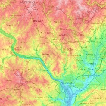
Name: Bethesda topographic map, elevation, terrain.

Location: Bethesda, Montgomery County, Maryland, 22814, United States (38.82483 -77.25465 39.14483 -76.93465)

Average elevation: 282 ft

Minimum elevation: -10 ft

Maximum elevation: 564 ft

Maryland trails, hiking, mountain biking, running and outdoor activities

Gear up for your next adventure:

🔌USB Car Charger - Car charger for on‑the‑go power needs
🥩Freeze-Dried Meals - Nutritious and lightweight food for remote expeditions
📻Weather Alert Radios - Stay informed of storm risks while off-the-grid
🏕️Family Camping Gear - Essentials for group camping trips
🧷Carabiner Set - Durable clips for gear attachment

As an Amazon Associate, this site earns from qualifying purchases at no extra cost to you.