Geolocate

Puquio topographic map

Click on the map to display elevation.

About this map

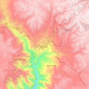
Name: Puquio topographic map, elevation, terrain.

Location: Puquio, Province of Lucanas, Ayacucho, Peru (-14.85786 -74.17776 -14.51286 -73.82561)

Average elevation: 12,293 ft

Minimum elevation: 6,296 ft

Maximum elevation: 15,295 ft

Other topographic maps

Click on a map to view its topography, its elevation and its terrain.

Atacocha

Peru > Ayacucho

Average elevation: 10,581 ft

Mejorada

Peru > Ayacucho > Unión Progreso

Average elevation: 3,885 ft

Palmadera

Peru > Ayacucho

Average elevation: 12,231 ft

Guitarrayoc

Peru > Ayacucho > Uspa

Average elevation: 4,974 ft

Santa Rosa

Peru > Ayacucho > San Juan Bautista

Average elevation: 9,160 ft

Guitarrayoc

Peru > Ayacucho > Uspa

Average elevation: 4,974 ft

Unya

Peru > Ayacucho

Average elevation: 9,603 ft

Pampas

Peru > Ayacucho > Luis Carranza

Average elevation: 10,062 ft

Cancha Cancha

Peru > Ayacucho

Average elevation: 11,050 ft

Tambobamba

Peru > Ayacucho

Average elevation: 9,724 ft

La Vega

Peru > Ayacucho

Average elevation: 9,459 ft

Santa Fe

Peru > Ayacucho

Average elevation: 14,836 ft

Apachita

Peru > Ayacucho > Vilcas Huamán > Alto Perú > Apachita

Average elevation: 11,483 ft

Villa Virgen

Peru > Ayacucho > Llochegua

Average elevation: 2,060 ft

Gear up for your next adventure:

🪑Ultralight Camp Chairs - Portable seating for resting after a long day of mapping
🔌Solar Panel Charger - Charge gear sustainably outdoors
🪶Survival Guide Book - Expert advice for emergency preparedness
🧯Emergency Survival Kit - All‑in‑one survival essentials for the backcountry
🔭Telescopic Hiking Pole - Adjustable pole for hiking stability

As an Amazon Associate, this site earns from qualifying purchases at no extra cost to you.