Geolocate

Tambobamba topographic map

Click on the map to display elevation.

About this map

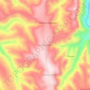
Name: Tambobamba topographic map, elevation, terrain.

Location: Tambobamba, Tambillo, Province of Huamanga, Ayacucho, Peru (-13.18680 -74.13594 -13.14680 -74.09594)

Average elevation: 9,724 ft

Minimum elevation: 8,753 ft

Maximum elevation: 10,180 ft

Other topographic maps

Click on a map to view its topography, its elevation and its terrain.

Puquio

Peru > Ayacucho

Average elevation: 12,293 ft

Soras

Peru > Ayacucho

Average elevation: 12,802 ft

Vinchos

Peru > Ayacucho

Average elevation: 12,349 ft

Province of Huanta

Peru > Ayacucho

Average elevation: 8,799 ft

Chilcas

Peru > Ayacucho

Average elevation: 10,564 ft

Santiago de Pischa

Peru > Ayacucho

Average elevation: 9,190 ft

Tambo

Peru > Ayacucho

Average elevation: 12,385 ft

San Juan Bautista

Peru > Ayacucho > San Juan Bautista

Average elevation: 10,026 ft

Tambo

Peru > Ayacucho

Average elevation: 12,385 ft

Gear up for your next adventure:

🧭Outdoor Navigation Book - Learn advanced navigation skills
🎁Geography Themed Gifts - Unique gift ideas for map lovers and geography enthusiasts
💧Water Filtration Bottles - Safely drink from streams and lakes while exploring
🧦Merino Wool Socks - Moisture-wicking, blister-preventing socks for long treks
Backpacking Tents - Weight-optimized shelters for multi-day topographic surveys

As an Amazon Associate, this site earns from qualifying purchases at no extra cost to you.