
Thank you for supporting this site ❤️
Make a donation
Make a donation
Gear up for your next adventure:
As an Amazon Associate, this site earns from qualifying purchases at no extra cost to you.
Buhatan topographic map
Click on the map to display elevation.
Thank you for supporting this site ❤️
Make a donation
Make a donation
Gear up for your next adventure:
As an Amazon Associate, this site earns from qualifying purchases at no extra cost to you.
About this map
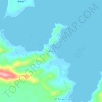
Name: Buhatan topographic map, elevation, terrain.
Location: Buhatan, Rapu-Rapu, Albay, Bicol Region, Philippines (13.26061 123.95607 13.30061 123.99607)
Average elevation: 56 ft
Minimum elevation: -3 ft
Maximum elevation: 545 ft
Thank you for supporting this site ❤️
Make a donation
Make a donation
Gear up for your next adventure:
As an Amazon Associate, this site earns from qualifying purchases at no extra cost to you.