Geolocate

Wanlin topographic map

Click on the map to display elevation.

About this map

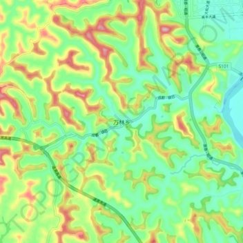
Name: Wanlin topographic map, elevation, terrain.

Location: Wanlin, Suining, Sichuan, China (30.77799 105.30325 30.85799 105.38325)

Average elevation: 1,276 ft

Minimum elevation: 997 ft

Maximum elevation: 1,759 ft

Other topographic maps

Click on a map to view its topography, its elevation and its terrain.

Hesha

China > Sichuan > Suining

Average elevation: 1,198 ft

Gear up for your next adventure:

🪶Wildlife Field Guides - Learn animal tracking and species ID
🥘Titanium Cookware - Durable, featherlight pots and pans for backpacking
🩹Survival Bandages - High‑quality bandages for emergencies
🪑Portable Camp Table - Compact table for campsite meals
🕶️Glacier Sunglasses - Side shields to protect eyes from high-altitude snow glare

As an Amazon Associate, this site earns from qualifying purchases at no extra cost to you.