

Redován topographic map
Click on the map to display elevation.
Redován
There appear to have been settlements on some small elevations of land in the surrounding areas from the Neolithic Period up until Bronze Age. In the 2nd century BC there appears to have been several different cultures in the region, among them “the culture of Argar” more commonly found in Almeria (further south down the coast of Spain). The area has always attracted settlers mostly because of its importance in agriculture due largely to the basin being irrigated by the Segura river, though there have often problems as the area is prone to flooding.
About this map
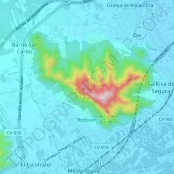
Name: Redován topographic map, elevation, terrain.
Average elevation: 226 ft
Minimum elevation: 36 ft
Maximum elevation: 1,788 ft
Other topographic maps
Click on a map to view its topography, its elevation and its terrain.
Torre de la Horadada
Spain > Valencian Community > el Baix Segura / La Vega Baja del Segura > Pilar de la Horadada
Average elevation: 16 ft
Playa Flamenca I
Spain > Valencian Community > el Baix Segura / La Vega Baja del Segura > Orihuela > Urbanización La Zenia
Average elevation: 82 ft
Urbanización Doña Pepa
Spain > Valencian Community > el Baix Segura / La Vega Baja del Segura > Rojales
Average elevation: 79 ft
Cabo Roig
Spain > Valencian Community > el Baix Segura / La Vega Baja del Segura > Orihuela
Average elevation: 30 ft
Dehesa de Campoamor
Spain > Valencian Community > el Baix Segura / La Vega Baja del Segura > Orihuela
Average elevation: 92 ft