
Thank you for supporting this site ❤️
Make a donation
Make a donation
Gear up for your next adventure:
As an Amazon Associate, this site earns from qualifying purchases at no extra cost to you.
Chaquilcasa topographic map
Click on the map to display elevation.
Thank you for supporting this site ❤️
Make a donation
Make a donation
Gear up for your next adventure:
As an Amazon Associate, this site earns from qualifying purchases at no extra cost to you.
About this map
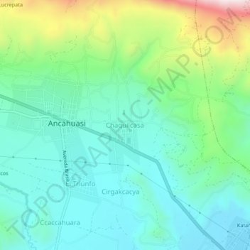
Name: Chaquilcasa topographic map, elevation, terrain.
Location: Chaquilcasa, Ancahuasi, Anta, Cusco, Perú (-13.47739 -72.31100 -13.43739 -72.27100)
Average elevation: 11,624 ft
Minimum elevation: 11,053 ft
Maximum elevation: 13,238 ft
Thank you for supporting this site ❤️
Make a donation
Make a donation
Gear up for your next adventure:
As an Amazon Associate, this site earns from qualifying purchases at no extra cost to you.