
Make a donation
Gear up for your next adventure:
As an Amazon Associate, this site earns from qualifying purchases at no extra cost to you.
Armoor topographic map
Click on the map to display elevation.
Make a donation
Gear up for your next adventure:
As an Amazon Associate, this site earns from qualifying purchases at no extra cost to you.
Armoor
Topography and Natural Features Armoor is located in the Deccan Plateau, characterized by its rugged terrain and basalt formations, a typical feature of this volcanic plateau region. One of the most notable geographical highlights is the “Navanatha Siddeshwara Temple Hill” – a large hill that not only holds spiritual significance but also provides a scenic view of the town and its surroundings. This hilly terrain, with its rocky outcrops and vegetation, gives the area its distinctive appearance.
Make a donation
Gear up for your next adventure:
As an Amazon Associate, this site earns from qualifying purchases at no extra cost to you.
About this map
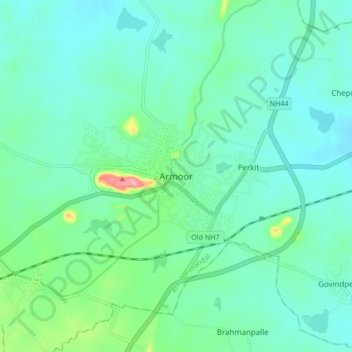
Name: Armoor topographic map, elevation, terrain.
Average elevation: 1,214 ft
Minimum elevation: 1,138 ft
Maximum elevation: 1,519 ft
Make a donation
Gear up for your next adventure:
As an Amazon Associate, this site earns from qualifying purchases at no extra cost to you.