
Bolsena topographic map
Interactive map
Click on the map to display elevation.
About this map
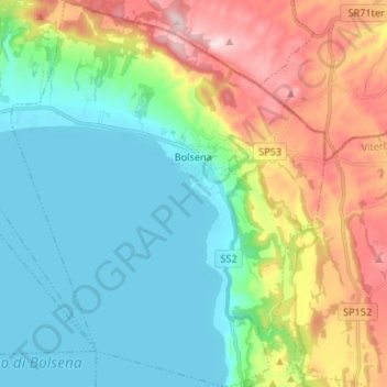
Name: Bolsena topographic map, elevation, terrain.
Location: Bolsena, Viterbe, Latium, 01023, Italie (42.58634 11.92250 42.68367 12.03000)
Average elevation: 1,388 ft
Minimum elevation: 994 ft
Maximum elevation: 2,231 ft
Other topographic maps
Click on a map to view its topography, its elevation and its terrain.
SIC Monti di Castro
Italie > Latium > Viterbe > Ischia di Castro
SIC Monti di Castro, Ischia di Castro, Unione di Comuni Montani Colline del Fiora, Viterbe, Latium, Italie
Average elevation: 850 ft
Poggio Morello
Italie > Latium > Viterbe > Viterbe
Poggio Morello, Viterbe, Latium, 01026, Italie
Average elevation: 699 ft
Montalto di Castro
Montalto di Castro, Viterbe, Latium, 01014, Italie
Average elevation: 157 ft
Montefiascone
Montefiascone, Viterbe, Latium, 01027, Italie
Average elevation: 1,230 ft
San Lorenzo Nuovo
San Lorenzo Nuovo, Viterbe, Latium, Italie
Average elevation: 1,325 ft
Pisciarello
Italie > Latium > Viterbe > Graffignano
Pisciarello, Graffignano, Viterbe, Latium, Italie
Average elevation: 341 ft