Geolocate

Bethel topographic map

Click on the map to display elevation.

About this map

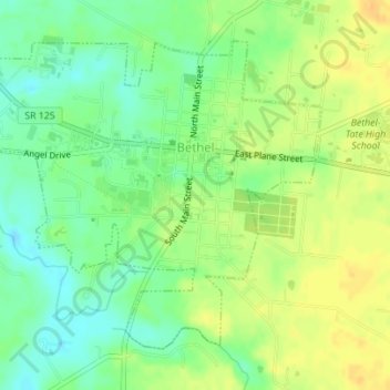
Name: Bethel topographic map, elevation, terrain.

Location: Bethel, Tate Township, Clermont County, Ohio, United States (38.94938 -84.10002 38.97364 -84.06689)

Average elevation: 889 ft

Minimum elevation: 840 ft

Maximum elevation: 932 ft

Clermont County trails, hiking, mountain biking, running and outdoor activities

Other topographic maps

Click on a map to view its topography, its elevation and its terrain.

The Highlands

United States > Ohio > Clermont County

Average elevation: 715 ft

Perintown

United States > Ohio > Clermont County

Average elevation: 653 ft

Cedron

United States > Ohio > Clermont County

Average elevation: 748 ft

Amelia

United States > Ohio > Clermont County

Average elevation: 869 ft

Hills

United States > Ohio > Clermont County

Average elevation: 797 ft

Saltair

United States > Ohio > Clermont County

Average elevation: 879 ft

The Highlands

United States > Ohio > Clermont County

Average elevation: 715 ft

The Highlands

United States > Ohio > Clermont County

Average elevation: 715 ft

Laurel

United States > Ohio > Clermont County

Average elevation: 827 ft

Tobasco

United States > Ohio > Clermont County > Tobasco

Average elevation: 883 ft

Gear up for your next adventure:

🚑Emergency Bivvies - Heat-reflective sleeping bags for survival situations
🧯Emergency Survival Kit - All‑in‑one survival essentials for the backcountry
🚗GPS Dash Cams - Record your scenic drives through mountain passes and canyons
🎁Geography Themed Gifts - Unique gift ideas for map lovers and geography enthusiasts
🧭Outdoor Navigation Book - Learn advanced navigation skills

As an Amazon Associate, this site earns from qualifying purchases at no extra cost to you.