
Make a donation
Gear up for your next adventure:
As an Amazon Associate, this site earns from qualifying purchases at no extra cost to you.
Ottobrunn topographic map
Click on the map to display elevation.
Make a donation
Gear up for your next adventure:
As an Amazon Associate, this site earns from qualifying purchases at no extra cost to you.
Ottobrunn
Die nächstgelegenen Wälder – der Höhenkirchener Forst, der Perlacher Forst, der Hofoldinger Forst und der Grünwalder Forst – befinden sich allesamt in einem Umkreis von höchstens zehn Kilometern. Unter den Naherholungsgebieten Oberbayerns sind der Starnberger See und der Tegernsee keine 40, der Schliersee knapp 45 und das Skigebiet am Brauneck bei Lenggries nicht ganz 55 Straßenkilometer von Ottobrunn entfernt.
Make a donation
Gear up for your next adventure:
As an Amazon Associate, this site earns from qualifying purchases at no extra cost to you.
About this map
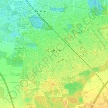
Name: Ottobrunn topographic map, elevation, terrain.
Location: Ottobrunn, Landkreis München, Bayern, 85521, Deutschland (48.05071 11.64305 48.07572 11.69504)
Average elevation: 1,834 ft
Minimum elevation: 1,785 ft
Maximum elevation: 1,873 ft
Make a donation
Gear up for your next adventure:
As an Amazon Associate, this site earns from qualifying purchases at no extra cost to you.
Other topographic maps
Click on a map to view its topography, its elevation and its terrain.