
Make a donation
Gear up for your next adventure:
As an Amazon Associate, this site earns from qualifying purchases at no extra cost to you.
Monte Cardo topographic map
Click on the map to display elevation.
Make a donation
Gear up for your next adventure:
As an Amazon Associate, this site earns from qualifying purchases at no extra cost to you.
About this map
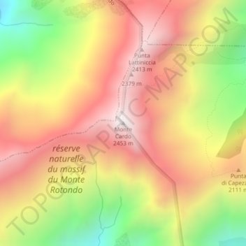
Name: Monte Cardo topographic map, elevation, terrain.
Average elevation: 6,421 ft
Minimum elevation: 4,393 ft
Maximum elevation: 7,989 ft
Make a donation
Gear up for your next adventure:
As an Amazon Associate, this site earns from qualifying purchases at no extra cost to you.
Other topographic maps
Click on a map to view its topography, its elevation and its terrain.
Réserve naturelle du Massif du Monte Ritondu
France > Corse > Haute-Corse > Venaco
Le territoire de la réserve naturelle est dans le département de la Haute-Corse, sur les communes de Corte et Venaco. Il englobe une zone de 3 135 ha autour du sommet du Monte Rotondo (2 622 m), second sommet de la Corse et regroupe la majorité des lacs d'altitude de Corse (lacs de l'Oriente, de Cavacciole,…
Average elevation: 4,662 ft