
Poonjar topographic map
Click on the map to display elevation.
About this map
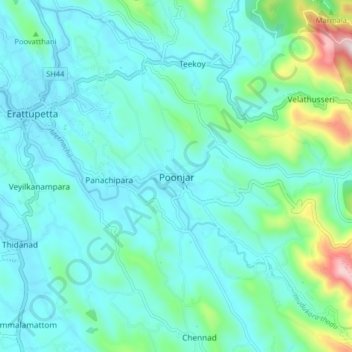
Name: Poonjar topographic map, elevation, terrain.
Location: Poonjar, Meenachil, Kottayam District, Kerala, 686581, India (9.63376 76.77303 9.71376 76.85303)
Average elevation: 404 ft
Minimum elevation: 56 ft
Maximum elevation: 2,136 ft
Other topographic maps
Click on a map to view its topography, its elevation and its terrain.
Cherppungal Kulam Cheripurathu Padasekaram Karikombu
India > Kerala > Meenachil > Cherpunkal
Average elevation: 95 ft