Geolocate
👉 Easily get elevation data in JSON, GeoTIFF and KML formats using Elevation API
Thank you for supporting this site ❤️
Make a donation

Murs topographic map

Click on the map to display elevation.

About this map

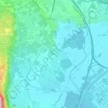
Name: Murs topographic map, elevation, terrain.

Location: Murs, Les Marches, Porte-de-Savoie, Chambéry, Savoie, Auvergne-Rhône-Alpes, France métropolitaine, 73800, France (45.46722 5.98291 45.50722 6.02291)

Average elevation: 945 ft

Minimum elevation: 814 ft

Maximum elevation: 1,709 ft

Other topographic maps

Click on a map to view its topography, its elevation and its terrain.

Les Marches

France > Auvergne-Rhône-Alpes > Savoie > Porte-de-Savoie

Ce territoire, de 1 535 hectares, est situé entre 254 m et 1 134 m d’altitude. Son relief est caractérisé par trois types de formes naturelles, façonnées pendant le Quaternaire et la période historique.

Average elevation: 1,273 ft

Francin

France > Auvergne-Rhône-Alpes > Savoie > Porte-de-Savoie

Average elevation: 1,030 ft

Les Marches

France > Auvergne-Rhône-Alpes > Savoie > Porte-de-Savoie

Ce territoire, de 1 535 hectares, est situé entre 254 m et 1 134 m d’altitude. Son relief est caractérisé par trois types de formes naturelles, façonnées pendant le Quaternaire et la période historique.

Average elevation: 1,273 ft

Gear up for your next adventure:

🛶Inflatable Kayak - Portable kayak for rivers, lakes, and expeditions
🪶Thermal Camp Blanket - Extra warmth for cold nights
🚑Emergency Bivvies - Heat-reflective sleeping bags for survival situations
🧥Waterproof Jacket for Hiking - Breathable and rugged rain jacket for outdoor excursions
🧤Tactile Hiking Gloves - Keep hands warm while operating GPS and smartphone screens

As an Amazon Associate, this site earns from qualifying purchases at no extra cost to you.