Geolocate

Geisa topographic map

Click on the map to display elevation.

About this map

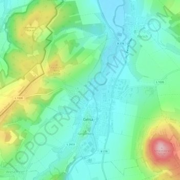
Name: Geisa topographic map, elevation, terrain.

Location: Geisa, Wartburgkreis, Thuringia, 36419, Germany (50.70182 9.92066 50.73940 9.98041)

Average elevation: 1,089 ft

Minimum elevation: 876 ft

Maximum elevation: 1,624 ft

Other topographic maps

Click on a map to view its topography, its elevation and its terrain.

Walkes

Germany > Thuringia > Wartburgkreis > Geisa

Average elevation: 1,598 ft

Gear up for your next adventure:

🧭GPS Watch Accessories - Bands and chargers for GPS watches
⛑️Personal Locator Beacon - Safety beacon for emergencies
🪶Multi‑Purpose Knife - Useful blade for camp and trail
🧯Emergency Survival Kit - All‑in‑one survival essentials for the backcountry
Backpacking Tents - Weight-optimized shelters for multi-day topographic surveys

As an Amazon Associate, this site earns from qualifying purchases at no extra cost to you.