
Alcanede topographic map
Interactive map
Click on the map to display elevation.
About this map
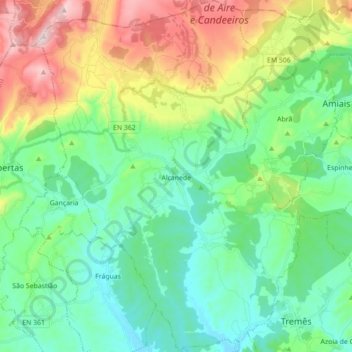
Name: Alcanede topographic map, elevation, terrain.
Location: Alcanede, Santarém, Portugal (39.34736 -8.89257 39.48301 -8.75887)
Average elevation: 568 ft
Minimum elevation: 95 ft
Maximum elevation: 1,716 ft
Other topographic maps
Click on a map to view its topography, its elevation and its terrain.
Vale de Figueira
Portugal > Santarém > Santarém
Vale de Figueira, Santarém, 2000-680, Portugal
Average elevation: 135 ft
Arneiro das Milhariças
Portugal > Santarém > Santarém
Arneiro das Milhariças, Santarém, Portugal
Average elevation: 338 ft