
White Island topographic map
Interactive map
Click on the map to display elevation.
About this map
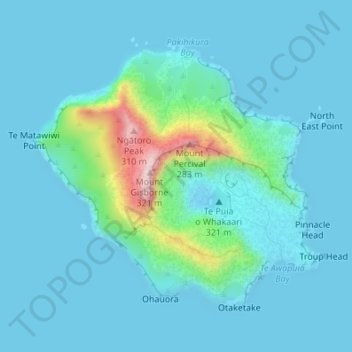
Name: White Island topographic map, elevation, terrain.
Location: White Island, Bay of Plenty, New Zealand (-37.53040 177.16694 -37.50976 177.19578)
Average elevation: 125 ft
Minimum elevation: -13 ft
Maximum elevation: 1,017 ft
Other topographic maps
Click on a map to view its topography, its elevation and its terrain.
Tauranga
New Zealand > Bay of Plenty > Tauranga City
Tauranga, Tauranga City, Bay of Plenty, 3110, New Zealand
Average elevation: 217 ft
Rotorua
New Zealand > Bay of Plenty > Rotorua Lakes District
Rotorua, Rotorua Lakes District, Bay of Plenty, 3010, New Zealand
Average elevation: 1,427 ft
Galatea
New Zealand > Bay of Plenty > Whakatane District
Galatea, Whakatāne District, Bay of Plenty, New Zealand
Average elevation: 571 ft
Edgecumbe
New Zealand > Bay of Plenty > Whakatane District
Edgecumbe, Whakatāne District, Bay of Plenty, 3193, New Zealand
Average elevation: 33 ft
Whakatāne
New Zealand > Bay of Plenty > Whakatane District
Whakatāne, Whakatāne District, Bay of Plenty, 3158, New Zealand
Average elevation: 98 ft
Waihi Beach
New Zealand > Bay of Plenty > Western Bay of Plenty District
Waihi Beach, Western Bay of Plenty District, Bay of Plenty, 3611, New Zealand
Average elevation: 190 ft
Papamoa
New Zealand > Bay of Plenty > Western Bay of Plenty District
Papamoa, Western Bay of Plenty District, Bay of Plenty, 3187, New Zealand
Average elevation: 259 ft
Lake Rotoiti / Te Roto kite ā Ihenga i ariki ai Kahu
New Zealand > Bay of Plenty > Rotorua Lakes District > Okere Falls
Lake Rotoiti / Te Roto kite ā Ihenga i ariki ai Kahu, Okere Falls, Rotorua Lakes District, Bay of Plenty, New Zealand
Average elevation: 1,230 ft
Thornton
New Zealand > Bay of Plenty > Whakatane District
Thornton, Whakatāne District, Bay of Plenty, New Zealand
Average elevation: 16 ft
Putaruru
New Zealand > Bay of Plenty > Western Bay of Plenty District
Putaruru, Western Bay of Plenty District, Bay of Plenty, New Zealand
Average elevation: 794 ft
Oropi
New Zealand > Bay of Plenty > Western Bay of Plenty District
Oropi, Western Bay of Plenty District, Bay of Plenty, 3173, New Zealand
Average elevation: 971 ft
Welcome Bay
New Zealand > Bay of Plenty > Tauranga City > Tauranga
Welcome Bay, Tauranga, Tauranga City, Bay of Plenty, 3175, New Zealand
Average elevation: 59 ft
Te Puke
New Zealand > Bay of Plenty > Western Bay of Plenty District
Te Puke, Western Bay of Plenty District, Bay of Plenty, 3182, New Zealand
Average elevation: 118 ft
Rangiwaea Island
New Zealand > Bay of Plenty > Western Bay of Plenty District
Rangiwaea Island, Western Bay of Plenty District, Bay of Plenty, New Zealand
Average elevation: 13 ft
Lake Okaro
New Zealand > Bay of Plenty > Rotorua Lakes District
Lake Okaro, Rotorua Lakes District, Bay of Plenty, New Zealand
Average elevation: 1,391 ft
Parinui
New Zealand > Bay of Plenty > Ōpōtiki District
Parinui, Ōpōtiki District, Bay of Plenty, 3162, New Zealand
Average elevation: 220 ft
Tanners Point
New Zealand > Bay of Plenty > Western Bay of Plenty District
Tanners Point, Western Bay of Plenty District, Bay of Plenty, New Zealand
Average elevation: 59 ft
Whitianga
New Zealand > Bay of Plenty > Ōpōtiki District
Whitianga, Ōpōtiki District, Bay of Plenty, 3162, New Zealand
Average elevation: 138 ft
Hamurana
New Zealand > Bay of Plenty > Rotorua Lakes District
Hamurana, Rotorua Lakes District, Bay of Plenty, 3096, New Zealand
Average elevation: 1,086 ft
Lake Tahuna
New Zealand > Bay of Plenty > Whakatane District
Lake Tahuna, Whakatāne District, Bay of Plenty, New Zealand
Average elevation: 125 ft
Pikowai
New Zealand > Bay of Plenty > Whakatane District
Pikowai, Whakatāne District, Bay of Plenty, New Zealand
Average elevation: 108 ft
Opotiki
New Zealand > Bay of Plenty > Ōpōtiki District
Opotiki, Ōpōtiki District, Bay of Plenty, 3122, New Zealand
Average elevation: 46 ft
Tokanui
New Zealand > Bay of Plenty > Whakatane District
Tokanui, Whakatāne District, Bay of Plenty, New Zealand
Average elevation: 1,145 ft
Whangaparaoa
Whangaparaoa, Opotiki District, Bay of Plenty, New Zealand
Average elevation: 115 ft
Papamoa
New Zealand > Bay of Plenty > Ōpōtiki District
Papamoa, Ōpōtiki District, Bay of Plenty, New Zealand
Average elevation: 1,785 ft
Ōhope
New Zealand > Bay of Plenty > Whakatane District
Ōhope, Whakatāne District, Bay of Plenty, 3121, New Zealand
Average elevation: 131 ft
Kaingaroa Forest
New Zealand > Bay of Plenty > Rotorua Lakes District
Kaingaroa Forest, Rotorua Lakes District, Bay of Plenty, New Zealand
Average elevation: 1,709 ft
Manawahe
New Zealand > Bay of Plenty > Whakatane District
Manawahe, Whakatane District, Bay of Plenty, New Zealand
Average elevation: 1,089 ft
Omokoroa Beach
New Zealand > Bay of Plenty > Western Bay of Plenty District
Omokoroa Beach, Western Bay of Plenty District, Bay of Plenty, 3114, New Zealand
Average elevation: 30 ft
Katikati
New Zealand > Bay of Plenty > Western Bay of Plenty District
Katikati, Western Bay of Plenty District, Bay of Plenty, 3129, New Zealand
Average elevation: 171 ft
Whakatane District
Whakatane District, Bay of Plenty, New Zealand
Average elevation: 1,365 ft
Ohiwa
New Zealand > Bay of Plenty > Ōpōtiki District
Ohiwa, Ōpōtiki District, Bay of Plenty, 3198, New Zealand
Average elevation: 36 ft
Pukehina Beach
New Zealand > Bay of Plenty > Western Bay of Plenty District
Pukehina Beach, Western Bay of Plenty District, Bay of Plenty, New Zealand
Average elevation: 10 ft
Orakei
New Zealand > Bay of Plenty > Whakatane District
Orakei, Whakatane District, Bay of Plenty, New Zealand
Average elevation: 1,493 ft
Tauranga
New Zealand > Bay of Plenty > Tauranga
Tauranga, Tauranga City, Bay of Plenty, New Zealand
Average elevation: 33 ft
Ohauiti
New Zealand > Bay of Plenty > Western Bay of Plenty District
Ohauiti, Western Bay of Plenty District, Bay of Plenty, New Zealand
Average elevation: 482 ft
Tiritiri
New Zealand > Bay of Plenty > Whakatane District
Tiritiri, Whakatane District, Bay of Plenty, New Zealand
Average elevation: 1,660 ft
Kauri Point
New Zealand > Bay of Plenty > Western Bay of Plenty District
Kauri Point, Western Bay of Plenty District, Bay of Plenty, New Zealand
Average elevation: 23 ft
Port Ohope
New Zealand > Bay of Plenty > Whakatane District
Port Ohope, Whakatane District, Bay of Plenty, New Zealand
Average elevation: 3 ft
Moturiki Island (Leisure Island)
New Zealand > Bay of Plenty > Tauranga
Moturiki Island (Leisure Island), Tauranga, Bay of Plenty, New Zealand
Average elevation: 26 ft
Lake Rotorua
New Zealand > Bay of Plenty > Rotorua Lakes District > Hamurana
Lake Rotorua, Hamurana, Rotorua Lakes District, Bay of Plenty, 3040, New Zealand
Average elevation: 981 ft
Motonui Island
Motonui Island, Bay of Plenty, New Zealand
Average elevation: 33 ft
Matahi
New Zealand > Bay of Plenty > Whakatane District > Matahi
Matahi, Whakatane District, Bay of Plenty, New Zealand
Average elevation: 902 ft
Kaharoa
New Zealand > Bay of Plenty > Ōpōtiki District
Kaharoa, Ōpōtiki District, Bay of Plenty, New Zealand
Average elevation: 2,365 ft
Matakana Island
New Zealand > Bay of Plenty > Western Bay of Plenty District > Ōmokoroa Beach
Matakana Island, Ōmokoroa Beach, Western Bay of Plenty District, Bay of Plenty, New Zealand
Average elevation: 10 ft
Ngongotaha
New Zealand > Bay of Plenty > Rotorua Lakes District
Ngongotaha, Rotorua Lakes District, Bay of Plenty, New Zealand
Average elevation: 1,112 ft
Wairoa River
New Zealand > Bay of Plenty > Western Bay of Plenty District
Wairoa River, Western Bay of Plenty District, Bay of Plenty, New Zealand
Average elevation: 220 ft
Waiotapu Village
New Zealand > Bay of Plenty > Rotorua District > Waiotapu Village
Waiotapu Village, Rotorua District, Bay of Plenty, New Zealand
Average elevation: 1,437 ft
Rotorua Lakes District
Rotorua Lakes District, Bay of Plenty, New Zealand
Average elevation: 1,325 ft