
Dachne topographic map
Click on the map to display elevation.
About this map
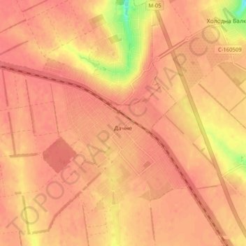
Name: Dachne topographic map, elevation, terrain.
Average elevation: 240 ft
Minimum elevation: 92 ft
Maximum elevation: 276 ft
Other topographic maps
Click on a map to view its topography, its elevation and its terrain.
Izmail
Ukraine > Odesa Oblast > Izmail
Under the Köppen classification, Izmail has a humid continental climate (Dfa) with four distinct seasons and generous precipitation year-round, typical for the inland South. Summers are hot and humid, with temperatures somewhat moderated by the city's elevation. Winters are cool but variable, with an average…
Average elevation: 62 ft