
Shawanaga Lake topographic map
Interactive map
Click on the map to display elevation.
About this map
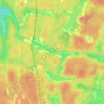
Name: Shawanaga Lake topographic map, elevation, terrain.
Average elevation: 830 ft
Minimum elevation: 735 ft
Maximum elevation: 873 ft
Other topographic maps
Click on a map to view its topography, its elevation and its terrain.
De Bois Lake
Canada > Ontario > Whitestone
De Bois Lake, Debois Trail, Whitestone, Parry Sound District, Central Ontario, Ontario, Canada
Average elevation: 840 ft
Blueberry Hill
Canada > Ontario > Whitestone
Blueberry Hill, Whitestone, Parry Sound District, Central Ontario, Ontario, Canada
Average elevation: 794 ft
Maple Island
Canada > Ontario > Whitestone
Maple Island, Whitestone, Parry Sound District, Central Ontario, Ontario, Canada
Average elevation: 896 ft
Highrock Lake
Canada > Ontario > Whitestone
Highrock Lake, Dobson Road, Whitestone, Parry Sound District, Central Ontario, Ontario, P0A 1G0, Canada
Average elevation: 938 ft
Oxbow Lake
Canada > Ontario > Whitestone
Oxbow Lake, 520, Whitestone, Parry Sound District, Ontario, Canada
Average elevation: 791 ft