Geolocate

Pemonte topographic map

Click on the map to display elevation.

About this map

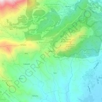
Name: Pemonte topographic map, elevation, terrain.

Location: Pemonte, Prascorsano, Torino, Piemonte, 10080, Italia (45.34435 7.60052 45.38435 7.64052)

Average elevation: 1,719 ft

Minimum elevation: 1,106 ft

Maximum elevation: 3,251 ft

Gear up for your next adventure:

🪶Trail Camera - Capture wildlife on your hikes
🛰️Handheld GPS Units - Professional satellite navigators for precise backcountry mapping
Backpacking Tents - Weight-optimized shelters for multi-day topographic surveys
🥄Camping Utensil Set - Lightweight utensils for outdoor meals
📖Nature Tracking Books - Learn to track wildlife and terrain

As an Amazon Associate, this site earns from qualifying purchases at no extra cost to you.