
Southern Leyte topographic map
Interactive map
Click on the map to display elevation.
About this map
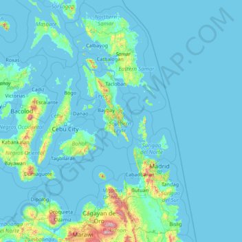
Name: Southern Leyte topographic map, elevation, terrain.
Location: Southern Leyte, Eastern Visayas, Philippines (7.78751 122.56509 12.90751 127.68509)
Average elevation: 279 ft
Minimum elevation: -7 ft
Maximum elevation: 9,177 ft
Along with other mountain forms in the province, Mount Nacolod in Hinunangan town has the highest peak with an elevation of 948 metres (3,110 ft) above sea level. Young volcanic rocks are discovered in the terrain areas, which cover the top of the southern mountain ranges of Mount Cabalian in the Pacific Area and Mount Nelangcapan in Panaon Area.
Other topographic maps
Click on a map to view its topography, its elevation and its terrain.
Limasawa
Limasawa, Southern Leyte, Eastern Visayas, 6618, Philippines
Average elevation: 3 ft
Hinunangan
Hinunangan, Southern Leyte, Eastern Visayas, 6608, Philippines
Average elevation: 115 ft
Macrohon
Macrohon, Southern Leyte, Eastern Visayas, 6601, Philippines
Average elevation: 341 ft
Silago
Silago, Southern Leyte, Eastern Visayas, Philippines
Average elevation: 348 ft
San Francisco
Philippines > Southern Leyte > San Francisco
San Francisco, Southern Leyte, Eastern Visayas, Philippines
Average elevation: 315 ft
Maasin
Philippines > Southern Leyte > Maasin
Maasin, Southern Leyte, Eastern Visayas, Philippines
Average elevation: 295 ft
San Juan
Philippines > Southern Leyte > San Juan
San Juan, Southern Leyte, Eastern Visayas, 6611, Philippines
Average elevation: 312 ft
Sogod
Sogod, Southern Leyte, Eastern Visayas, Philippines
Average elevation: 308 ft
Poblacion
Philippines > Southern Leyte > Liloan > Poblacion
Poblacion, Liloan, Southern Leyte, Eastern Visayas, 6612, Philippines
Average elevation: 62 ft