
Thank you for supporting this site ❤️
Make a donation
Make a donation
Gear up for your next adventure:
As an Amazon Associate, this site earns from qualifying purchases at no extra cost to you.
Round Lake topographic map
Click on the map to display elevation.
Thank you for supporting this site ❤️
Make a donation
Make a donation
Gear up for your next adventure:
As an Amazon Associate, this site earns from qualifying purchases at no extra cost to you.
About this map
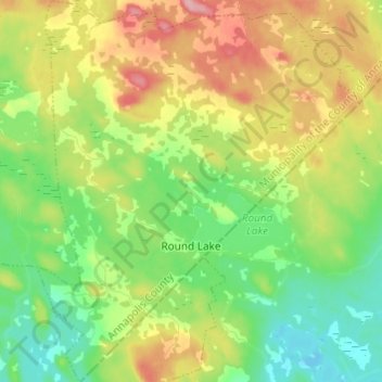
Name: Round Lake topographic map, elevation, terrain.
Average elevation: 515 ft
Minimum elevation: 354 ft
Maximum elevation: 764 ft
Thank you for supporting this site ❤️
Make a donation
Make a donation
Gear up for your next adventure:
As an Amazon Associate, this site earns from qualifying purchases at no extra cost to you.
Other topographic maps
Click on a map to view its topography, its elevation and its terrain.
Black Rattle
Canada > Nova Scotia > Municipality of the County of Annapolis > Cloud Lake
Average elevation: 623 ft
Eleven Mile Lake
Canada > Nova Scotia > Municipality of the County of Annapolis > Nine Mile Woods
Average elevation: 528 ft