
Make a donation
Gear up for your next adventure:
As an Amazon Associate, this site earns from qualifying purchases at no extra cost to you.
Osburg topographic map
Click on the map to display elevation.
Make a donation
Gear up for your next adventure:
As an Amazon Associate, this site earns from qualifying purchases at no extra cost to you.
Osburg
Das Klima des Ortes Osburg sowie des gesamten Osburger Hochwaldes als Teil des Hunsrück ist ozeanisch geprägt. Die Sommer sind recht kühl, die Winter -im Vergleich zu weiter östlich gelegenen Mittelgebirgen- eher mild, aber auf Grund der Höhenlage und häufiger Niederschläge im Winter, durchaus schneereich.
Make a donation
Gear up for your next adventure:
As an Amazon Associate, this site earns from qualifying purchases at no extra cost to you.
About this map
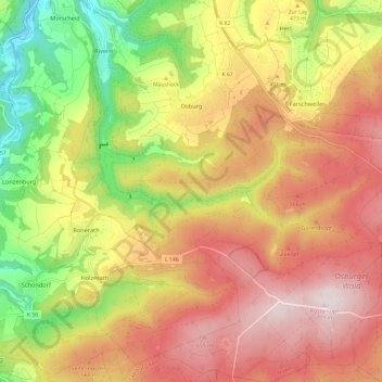
Name: Osburg topographic map, elevation, terrain.
Average elevation: 1,526 ft
Minimum elevation: 558 ft
Maximum elevation: 2,343 ft
Make a donation
Gear up for your next adventure:
As an Amazon Associate, this site earns from qualifying purchases at no extra cost to you.
Other topographic maps
Click on a map to view its topography, its elevation and its terrain.