
Kerniel topographic map
Click on the map to display elevation.
Kerniel
Kerniel bevindt zich in Vochtig-Haspengouw op een hoogte tussen 60 en 105 meter. Het ligt op de Steilrand van Borgloon, waar het Haspengouws Plateau naar het noorden toe snel afloopt van meer dan 100 tot 60 meter hoogte. Deze steilrand vormt ook de grens met het, zuidelijk gelegen, Droog-Haspengouw.
About this map
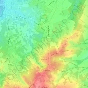
Name: Kerniel topographic map, elevation, terrain.
Location: Kerniel, Borgloon, Tongeren, Limburg, Vlaanderen, België (50.80464 5.34646 50.84270 5.38958)
Average elevation: 246 ft
Minimum elevation: 131 ft
Maximum elevation: 384 ft
Other topographic maps
Click on a map to view its topography, its elevation and its terrain.