
Thank you for supporting this site ❤️
Make a donation
Make a donation
Gear up for your next adventure:
As an Amazon Associate, this site earns from qualifying purchases at no extra cost to you.
Cipasung topographic map
Click on the map to display elevation.
Thank you for supporting this site ❤️
Make a donation
Make a donation
Gear up for your next adventure:
As an Amazon Associate, this site earns from qualifying purchases at no extra cost to you.
About this map
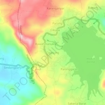
Name: Cipasung topographic map, elevation, terrain.
Location: Cipasung, Kuningan, West Java, Java, 45562, Indonesia (-7.03525 108.37613 -6.99525 108.41613)
Average elevation: 2,359 ft
Minimum elevation: 1,903 ft
Maximum elevation: 2,907 ft
Thank you for supporting this site ❤️
Make a donation
Make a donation
Gear up for your next adventure:
As an Amazon Associate, this site earns from qualifying purchases at no extra cost to you.
Other topographic maps
Click on a map to view its topography, its elevation and its terrain.
Gunung Ciremai National Park
Indonesia > West Java > Kuningan > Padabeunghar
Average elevation: 2,881 ft