
Make a donation
Gear up for your next adventure:
As an Amazon Associate, this site earns from qualifying purchases at no extra cost to you.
Bantul Regency topographic map
Click on the map to display elevation.
Make a donation
Gear up for your next adventure:
As an Amazon Associate, this site earns from qualifying purchases at no extra cost to you.
About this map
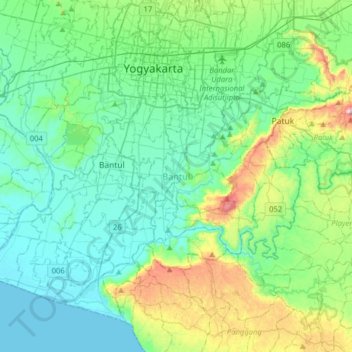
Name: Bantul Regency topographic map, elevation, terrain.
Average elevation: 420 ft
Minimum elevation: 0 ft
Maximum elevation: 1,995 ft
Make a donation
Gear up for your next adventure:
As an Amazon Associate, this site earns from qualifying purchases at no extra cost to you.
Other topographic maps
Click on a map to view its topography, its elevation and its terrain.
Wisdom park
Indonesia > Special Region of Yogyakarta > Sleman Regency > Catur tunggal
Average elevation: 446 ft
Gunung Malang
Indonesia > Special Region of Yogyakarta > Bantul Regency > Segoroyoso
Average elevation: 246 ft
Make a donation
Gear up for your next adventure:
As an Amazon Associate, this site earns from qualifying purchases at no extra cost to you.
Sungai Code
Indonesia > Special Region of Yogyakarta > Sleman Regency > Yogyakarta
Average elevation: 361 ft
Pantai Drini
Indonesia > Special Region of Yogyakarta > Gunung Kidul Regency > Banjarejo
Average elevation: 66 ft
Make a donation
Gear up for your next adventure:
As an Amazon Associate, this site earns from qualifying purchases at no extra cost to you.
Pantai Ngandong
Indonesia > Special Region of Yogyakarta > Gunung Kidul Regency > Sidoharjo
Average elevation: 75 ft
Gedangan
Indonesia > Special Region of Yogyakarta > Gunung Kidul Regency > Gedangsari > Hargomulyo
Average elevation: 1,066 ft
Samigaluh
Indonesia > Special Region of Yogyakarta > Kulon Progo > Gerbosari
Average elevation: 1,798 ft
Cangkringan
Indonesia > Special Region of Yogyakarta > Sleman Regency > Argomulyo
Average elevation: 1,486 ft
Make a donation
Gear up for your next adventure:
As an Amazon Associate, this site earns from qualifying purchases at no extra cost to you.
Kelurahan Ngargosari
Indonesia > Special Region of Yogyakarta > Kulon Progo > Ngargosari
Average elevation: 2,018 ft
Lumbung Rejo
Indonesia > Special Region of Yogyakarta > Sleman Regency > Lumbungrejo
Average elevation: 1,109 ft
taman sari
Indonesia > Special Region of Yogyakarta > Sleman Regency > Sinduharjo
Average elevation: 568 ft
Make a donation
Gear up for your next adventure:
As an Amazon Associate, this site earns from qualifying purchases at no extra cost to you.
Tlogo Putri Kaliurang
Indonesia > Special Region of Yogyakarta > Sleman Regency > Hargobinangun > Kaliurang
Average elevation: 3,110 ft
Sumber Rejo
Indonesia > Special Region of Yogyakarta > Sleman Regency > Sumberrejo
Average elevation: 764 ft
Pakem Binangun
Indonesia > Special Region of Yogyakarta > Sleman Regency > Pakembinangun
Average elevation: 1,470 ft
Pantai Krakal Barat
Indonesia > Special Region of Yogyakarta > Gunung Kidul Regency > Kanigoro
Average elevation: 89 ft
Make a donation
Gear up for your next adventure:
As an Amazon Associate, this site earns from qualifying purchases at no extra cost to you.
Karang Sari
Indonesia > Special Region of Yogyakarta > Gunung Kidul Regency > Karangsari
Average elevation: 1,142 ft
SUNGAI OPAK
Indonesia > Special Region of Yogyakarta > Sleman Regency > Leses
Average elevation: 774 ft
Kalasan
Indonesia > Special Region of Yogyakarta > Sleman Regency > Tirtomartani
Average elevation: 469 ft
Minggir
Indonesia > Special Region of Yogyakarta > Sleman Regency > Sendangagung
Average elevation: 466 ft
Make a donation
Gear up for your next adventure:
As an Amazon Associate, this site earns from qualifying purchases at no extra cost to you.
Margoagung
Indonesia > Special Region of Yogyakarta > Sleman Regency > Margoagung
Average elevation: 636 ft
Kemiri Kebo
Indonesia > Special Region of Yogyakarta > Sleman Regency > Girikerto
Average elevation: 2,339 ft
Tempel
Indonesia > Special Region of Yogyakarta > Sleman Regency > Lumbungrejo
Average elevation: 1,060 ft
Make a donation
Gear up for your next adventure:
As an Amazon Associate, this site earns from qualifying purchases at no extra cost to you.
Pantai Porok
Indonesia > Special Region of Yogyakarta > Gunung Kidul Regency > Kemadang
Average elevation: 66 ft
Waduk Sermo
Indonesia > Special Region of Yogyakarta > Kulon Progo > Hargowilis
Average elevation: 561 ft
Ngasemayu
Indonesia > Special Region of Yogyakarta > Gunung Kidul Regency > Patuk
Average elevation: 728 ft
Ngipiksari
Indonesia > Special Region of Yogyakarta > Sleman Regency > Hargobinangun > Kaliurang
Average elevation: 2,605 ft
Make a donation
Gear up for your next adventure:
As an Amazon Associate, this site earns from qualifying purchases at no extra cost to you.
Margo Rejo
Indonesia > Special Region of Yogyakarta > Sleman Regency > Margorejo
Average elevation: 997 ft
Sepanjang Beach
Indonesia > Special Region of Yogyakarta > Gunung Kidul Regency > Kemadang
Average elevation: 49 ft
Make a donation
Gear up for your next adventure:
As an Amazon Associate, this site earns from qualifying purchases at no extra cost to you.
Jogotirto
Indonesia > Special Region of Yogyakarta > Sleman Regency > Jogotirto
Average elevation: 315 ft
Kaliurang
Indonesia > Special Region of Yogyakarta > Sleman Regency > Hargobinangun
Average elevation: 2,815 ft
Ngoro Oro
Indonesia > Special Region of Yogyakarta > Gunung Kidul Regency > Ngoro-oro > Ngoro Oro
Average elevation: 955 ft
Embung Tambakboyo
Indonesia > Special Region of Yogyakarta > Sleman Regency > Condongcatur > Condong Catur
Average elevation: 538 ft
Make a donation
Gear up for your next adventure:
As an Amazon Associate, this site earns from qualifying purchases at no extra cost to you.
Jomegatan
Indonesia > Special Region of Yogyakarta > Bantul Regency > Bugisan
Average elevation: 305 ft
Bangun Kerto
Indonesia > Special Region of Yogyakarta > Sleman Regency > Bangunkerto
Average elevation: 1,243 ft
Pantai Jungwok
Indonesia > Special Region of Yogyakarta > Gunung Kidul Regency > Jepitu
Average elevation: 49 ft
Gapuro Gedongkuning
Indonesia > Special Region of Yogyakarta > Bantul Regency > Banguntapan
Average elevation: 338 ft
Make a donation
Gear up for your next adventure:
As an Amazon Associate, this site earns from qualifying purchases at no extra cost to you.