
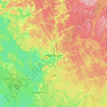
Bracebridge topographic map
Interactive map
Click on the map to display elevation.
About this map
Name: Bracebridge topographic map, elevation, terrain.
Average elevation: 932 ft
Minimum elevation: 676 ft
Maximum elevation: 1,306 ft
Other topographic maps
Click on a map to view its topography, its elevation and its terrain.
Stewart Lake
Canada > Ontario > Muskoka District > Georgian Bay Township > MacTier
Stewart Lake, MacTier, Georgian Bay Township, District Municipality of Muskoka, Muskoka District, Central Ontario, Ontario, Canada
Average elevation: 791 ft
Lake of Bays Township
Canada > Ontario > Muskoka District > Dorset
Lake of Bays Township, Dorset, District Municipality of Muskoka, Muskoka District, Central Ontario, Ontario, P0A 1E0, Canada
Average elevation: 1,158 ft
Little Margaret Lake
Canada > Ontario > Muskoka District
Little Margaret Lake, Lake of Bays Township, District Municipality of Muskoka, Muskoka District, Central Ontario, Ontario, Canada
Average elevation: 1,217 ft
Bala Park Island
Canada > Ontario > Muskoka District > Muskoka Lakes Township > Bala
Bala Park Island, Bala, Muskoka Lakes Township, District Municipality of Muskoka, Muskoka District, Central Ontario, Ontario, Canada
Average elevation: 748 ft
Palette Lake
Canada > Ontario > Muskoka District > Huntsville
Palette Lake, Huntsville, District Municipality of Muskoka, Muskoka District, Central Ontario, Ontario, Canada
Average elevation: 1,155 ft
Lake Rosseau
Canada > Ontario > Muskoka District > Muskoka Lakes Township
Lake Rosseau, Muskoka Lakes Township, District Municipality of Muskoka, Muskoka District, Central Ontario, Ontario, Canada
Average elevation: 820 ft
Baysville
Canada > Ontario > Muskoka District > Baysville
Baysville, Lake of Bays Township, District Municipality of Muskoka, Muskoka District, Central Ontario, Ontario, Canada
Average elevation: 1,122 ft
Huntsville
Canada > Ontario > Muskoka District
Huntsville, District Municipality of Muskoka, Muskoka District, Central Ontario, Ontario, Canada
Average elevation: 1,102 ft
Lake of Bays Township
Canada > Ontario > Muskoka District
Lake of Bays Township, District Municipality of Muskoka, Muskoka District, Central Ontario, Ontario, Canada
Average elevation: 1,230 ft
Gravenhurst
Canada > Ontario > Muskoka District
Gravenhurst, District Municipality of Muskoka, Muskoka District, Central Ontario, Ontario, Canada
Average elevation: 801 ft
MacTier
Canada > Ontario > Muskoka District > Georgian Bay Township
MacTier, Georgian Bay Township, District Municipality of Muskoka, Muskoka District, Central Ontario, Ontario, Canada
Average elevation: 791 ft
District Municipality of Muskoka
Canada > Ontario > Muskoka District
District Municipality of Muskoka, Muskoka District, Central Ontario, Ontario, Canada
Average elevation: 978 ft
Honey Harbour
Canada > Ontario > Muskoka District > Georgian Bay Township
Honey Harbour, Georgian Bay Township, District Municipality of Muskoka, Muskoka District, Central Ontario, Ontario, P0E 1E0, Canada
Average elevation: 600 ft