Geolocate

Harike topographic map

Click on the map to display elevation.

About this map

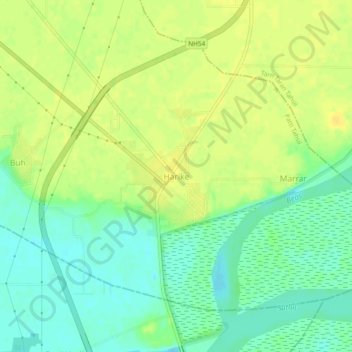
Name: Harike topographic map, elevation, terrain.

Location: Harike, Patti Tahsil, Tarn Taran, Punjab, 143412, India (31.14748 74.92486 31.18748 74.96486)

Average elevation: 705 ft

Minimum elevation: 666 ft

Maximum elevation: 738 ft

Gear up for your next adventure:

🪶Survival Guide Book - Expert advice for emergency preparedness
🥤Water Filter Bottle - All‑in‑one filter bottle for safe hydration
📚USA Hiking Guide Books - Top trail guides and map books
🔌USB Car Charger - Car charger for on‑the‑go power needs
📶Satellite Messenger - Communication device off‑grid

As an Amazon Associate, this site earns from qualifying purchases at no extra cost to you.